Culture
Every place in Rhode Island has a story of its own. Old stone walls remind us that forests once were fields; moraines and kettle ponds reveal where glaciers once stood; archeologists discover ancient piles of oyster shells that show us where the first Americans once lived their lives.
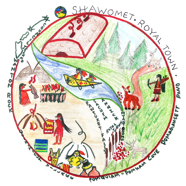
Our story of the Warwick coastline between Pawtuxet Village and Passeonkquis Cove begins with the Native Americans, who arrived at least 4,000 years ago. The Narragansett tribe called the area Choppequonsett. For generations, they farmed, fished and hunted, enjoying an abundance of natural resources. But by the 1700s, European immigrants had displaced the Natives. (An annotated version of the drawing in available in Resources under Culture.)

In the mid-1800s, Nicholas and Caroline Brown built an Italianate villa on the hillside. This eventually became the headquarters of the Chopequonsett Country Club, later reorganized as a Golf Club, only to burn down in 1897. E.T. Wyman Elementary School was eventually built atop the site of the old club house.


In the late 1800s, the area that is now the park became the Warwick Downs summer colony, where urban residents built cottages to enjoy weekends boating, swimming, berry-picking, and shellfishing along the shore. In the early 1900s, Warwick Downs and eventually Rock Island became the Narragansett Parkway Reservation, which started as a gravel road running through a green strip.
The cottages were razed by 1967, when the park was dedicated in honor of George B. Salter, the Ward One councilman. The Downs had been the site of many clambakes, bonfires, and dances, and is still fondly remembered by many local residents.
After Hurricane Carol in 1954, a group of local yachtsmen lobbied the State to build a breakwater to protect the harbor and the boat basin. The breakwater was completed in 1965. The causeway leading to the breakwater was never meant to be a permanent feature — it was built just as a means to carry the stones out to the breakwater.

The then Department of Natural Resources requested that the causeway remain in place to provide recreational fishing opportunities, as it continues to do. The RI Department of Environmental Management remains responsible for the causeway, and the U.S. Army Corps of Engineers for the breakwater, while the City of Warwick has maintained the mainland and Rock and Marsh Islands since 1994.


In the above slideshow, a series of aerial photos at approximately decadal intervals from 1939 to 2019 illustrates the changes as the Gaspee Plateau residential neighborhood was developed in the late 1940s. The popular Third Beach at the northwest corner of the park (mainland portion outlined in blue), together with the summer colony of Warwick Downs, had disappeared by the 1960s when the breakwater was built.
Industries and urban areas surrounding the upper bay had used the rivers and coastal waters as a dumping ground for industrial wastes and sewage. In the 1970s, local environmental groups, led by Save The Bay, began working to clean up sewage-treatment plants, shut down industrial polluters, and prevent stormwater overflows. These efforts have led to noticeable improvements in water quality and marine life.
Friends of Salter Grove launched in February 2016 to help bring the park’s neighbors together to work with the City of Warwick, the state Department of Environmental Management, Save The Bay, and all other interested parties to realize the potential of this coastal suburban park.


...
Repair of the causeway and replacement of the playground in 2019, at the instigation of the Friends of Salter Grove and with the support of RIDEM and the City of Warwick, greatly improved their safety and utility.
Additional information is available in Resources under Culture.