Geology
The geology of Salter Grove depends on three major processes—plate tectonics , sedimentation , and glaciation . Except for glaciation, these processes are ongoing in the region, but their significance in shaping the modern landscape is sequential so we will discuss them in turn.
Plate tectonics
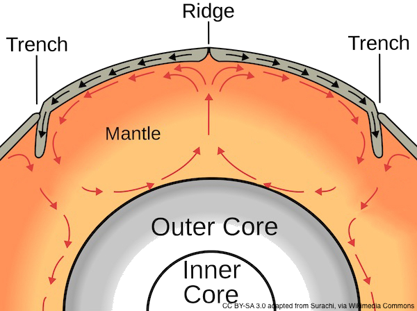
The outermost layers of the earth consist of large rock slabs called plates, which are up to 60 miles thick. Convection within the warm, but solid, 400-mile deep mantle beneath the plates causes them to move.
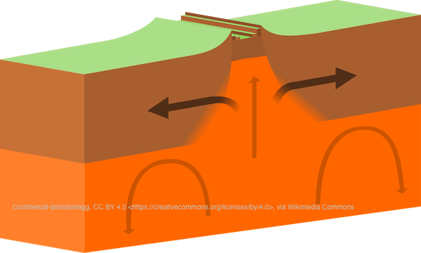
Plates of continental or oceanic crust can move away from each other, toward each other, or sideways past each other. When plates diverge, new ocean crust forms at spreading ridges. If this continues, an ocean basin forms.
At least three plate collisions have occurred in New England in the past 500 million years. When a denser oceanic plate collides with a continental plate, it sinks beneath (subduction zone). Soft sediments on the ocean floor are scraped and pushed into a wedge that is added to the continent above the subduction zone.
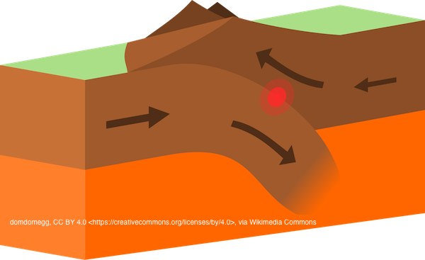
Subduction zones consume large masses of rocks as heat and pressure soften and ultimately melt the sinking oceanic rocks. Some becomes magma, which rises along fractures and may erupt as volcanic lava where the fracture reaches the earth’s surface. These balanced processes of creation and consumption explain why the earth does not increase in size.
About 750 million years ago, a rift created the continent Laurentia, which became the nucleus for North America, whose eastern coast then was today’s western Connecticut. Everything to the east was added later, piece by piece, as you can follow in this animation. (Enter Warwick, RI in box at upper left, uncheck all Display options at upper right, then use your keyboard's left and right arrow keys to go back and forth in time.)
A co-existing supercontinent Gondwana comprised, in part, a volcanic arc named Avalonia, adjacent to what became present-day West Africa. This is revealed by their shared fossil trilobite fauna.
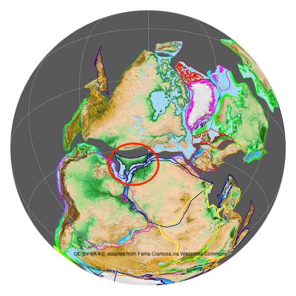
Avalonia (red circle) diverged from Gondwana approximately 465 million years ago, moving across the early Atlantic Ocean to collide with Laurentia (contient to north) 425 to 370 million years ago. This collision is named the Acadian Orogeny.
It altered the topography from Alabama to the Canadian Maritimes, developing large mountains in New England. Rhode Island is the only state in New England formed entirely atop basal rock from the microcontinent Avalonia.
From 350 to 250 million years ago, a subsequent collision, called the Alleghanian Orogeny, resulted in the reuniting of Gondwana with Laurentia, forming the supercontinent Pangea. The Alleghenian Orogeny formed enormous mountains, the eroded remnants of which are today’s Appalachians.
This large continental mass, with its high mountains, heated up the mantle below, and Pangea began to rift apart. The breakup, about 200 million years ago, produced the modern continents of North America and Europe and the Atlantic Ocean between them.
Sedimentation

Over long periods of time, rocks are broken down by weathering. Wind, water, ice, and gravity carry the loose material away and deposit it elsewhere. The soft sediments may eventually harden into solid sedimentary rock. This may be compacted by burial or cemented by a natural agent, such as iron oxide.
The forces inside the earth drive the rock cycle because compression builds mountains that erode, and extension builds basins where eroded sediments accumulate.
After Avalonia was welded to Laurentia about 400 million years ago, rift basins formed where the earth’s crust was stretched apart by tectonic forces. These basins then filled with sediments that are mostly 300 million years old. Among them was the Narragansett Basin, which now contains a calculated thickness of 12,000 feet of clastic sedimentary rocks. This geological basin includes, but substantially exceeds the Narragansett Bay, by extending northeastward into Massachusetts.
The structure of these sediments indicates that they were deposited in an alluvial, non-marine environment. Overlying the basal rock at Salter Grove is the Rhode Island Formation, a thick, extensive unit characterized by sandstone with numerous beds of conglomerate and siltstone. Granitic detritus, prominent in many of the sandstone and conglomerates, was probably derived from today’s Alleghenies to the west.
Glaciation
Rhode Island was glaciated twice in the last 2.5 million years. The more recent glaciation was called the Laurentide Ice Sheet, and it was approximately 2,000 feet thick in Narragansett Bay. The ice sheet reached its maximum southern extent along Long Island, New York. The glaciers could drag rocks from great distances, as seen by the granite bolulder from Massachusetts at Station V.
When the glacier began to melt in place 17,000 years ago, stagnant ice pulled along abundant amounts of sediment, and the resulting meltwater left the topography we have (streams, lakes, ponds, and sand deposits). In the Salter Grove area, these sediments were carried away from the glacier by streams of meltwater and deposited in an outwash plain. The soils derived from outwash tend to be thick, well sorted layers of sediment with stratified layers of sand and gravel.

Additional information is available in Resources under Geology.