Weather
The weather of Salter Grove in not distinct from that of upper Narragansett Bay, or southern New England, for that matter. Globally, solar radiation is the driving force behind all weather, which in turn drives the water cycle that enables life. We will take up these topics in turn, and then enjoy some attractive atmospheric phenomena .
Solar radiation
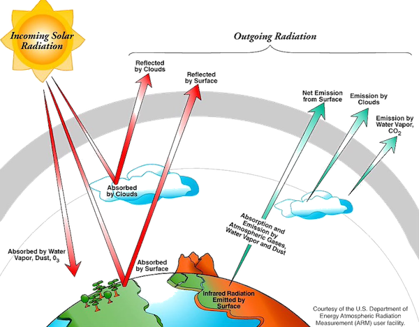
The atmosphere is constantly converting the sun’s energy from one form to another and moving it around. The atmosphere loses more solar radiation than it absorbs, due to reflection and scattering. The Earth’s surface has a solar energy surplus, which is converted to invisible long infrared waves that re-enter the atmosphere.
The invisible long-wave radiation from the Earth’s surface is more important to weather than the short-wave sunlight that passes directly through the atmosphere. It is also responsible for the greenhouse effect.
The system acts to even out imbalances by transferring energy from the earth’s surface to the atmosphere via conduction. Convection then mixes it through winds and other weather processes among the higher layers of the atmosphere. Conduction is why your feet feel cold on a tile floor, and convection is what happens when a pot of water boils. Convection creates a turbulent mess in the atmosphere, which is partly why the weather is difficult to predict.
Nevertheless, there is some order in the system when we look at three important elements of Earth’s relationship with the Sun. These are the Earth’s (i) year-long orbit around the Sun, (ii) tilt that gives the year its seasons, and (iii) daily rotation that produces diurnal weather variations.
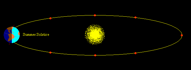
The Earth’s elliptical orbit around the Sun accounts for the annual repetition of the seasons, but not for the seasons themselves. Although Earth is 3% closer to the Sun in Salter Grove’s (and the northern hemisphere’s) winter, it gets 7% more heat energy in summer.
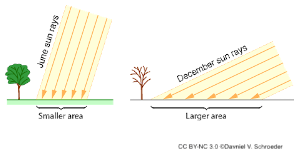
The closer together the Sun’s rays, the more intense the energy. Due to Earth’s tilt, the Sun’s rays strike it in winter at a greater angle and travel through more atmosphere, and so are less intense. This also explains why the polar regions are colder than the equator, but this would be true even if Earth was not tilted.
Finally, the rotation or spin of the earth has a large impact on daily weather by causing new areas to be warmed and cooled (shaded). This constant routine causes radiant energy to travel through the atmosphere like a wave. Weather patterns in the middle latitudes, where Salter Gove is located, move from west to east because of the earth’s spin. That spin is also responsible for the west-to-east direction of the powerful polar jet streams, and the prevailing mid-latitude westerlies.
Daily breezes at Salter Grove are created by regular circulations formed by the different ways that water and land handle heat. During the day, the land warms quickly and starts radiating heat away. The warm air rises, forming an area of relatively low pressure (and allowing certain birds like Osprey to soar). Water absorbs heat more slowly and keeps it much longer so the air pressure over water remains relatively constant. Air follows the pressure gradient, and a breeze blows from sea to land. At night the pressure gradients and wind direction are reversed.
Water cycle
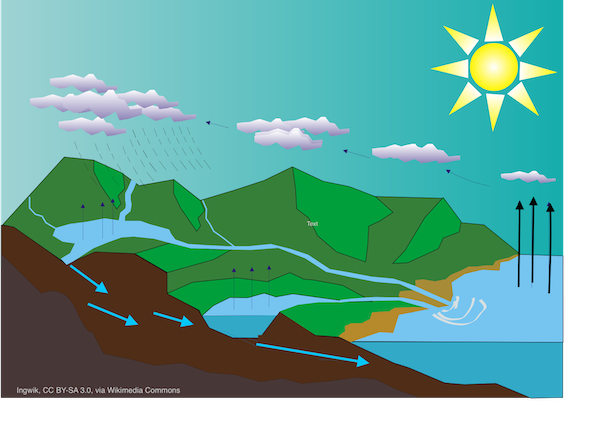
Precipitation, the liquid and solid water particles that fall from the sky, is part of the water cycle that sustains life. Weather drives this cycle by changing water’s from from gas to liquid to solid. The water cycle is constantly transferring Earth’s water supply among three basic reservoirs: the oceans (97%), the land, and the atmosphere.
Of all the water that enters the atmosphere, 84% evaporates from the oceans (92 quadrillion gallons per year), especially in the tropics, and the remainder from the continents. A molecule of water will spend seven to ten days in the atmosphere, where it may travel, on average, 6,000 miles east or west and 600 miles north or south. There’s no question about the global nature of the water economy!
Moist air cools as it rises, and when it reaches a certain point of saturation (the dew point) the water vapor in it condenses into water droplets. These droplets are about one thousandths of an inch across—the stuff of clouds and fog. It takes about a million of these droplets to form a rain drop when they meet on the surface of microscopic dust or aerosols. If the cloud is cold enough, ice crystals will condense and join together as snowflakes instead.

Which is colder—the air containing this fog or the Providence River?
Answer:
The river.
When rain drops or snowflakes become too heavy to remain in the cloud, they fall as precipitation. Most precipitation falls as rain, and 77% falls in the oceans. What falls on land eventually reaches the oceans through overland flow and seepage due to gravity. Thus, the water cycle is completed.
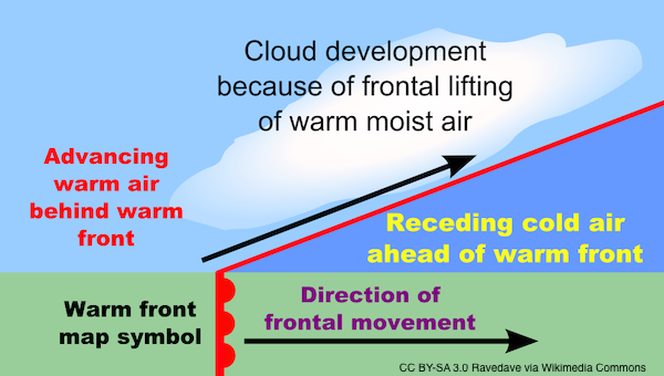
Both cold fronts and warm fronts cause air to rise, and therefore cause precipitation. A cold front is fast moving, typically traveling across the landscape at 30 miles per hour. The blunt nose of this dense air lifts retreating warm air at their boundary, where vertical clouds form.
An advancing warm front moves more slowly, at ten to 20 miles per hour because cold, dense air is hard to push. The warm air gradually rides over the top of the retreating cold air. Thickening layers of clouds form ahead of the frontal boundary and drop precipitation that is usually slow, steady, and widespread.

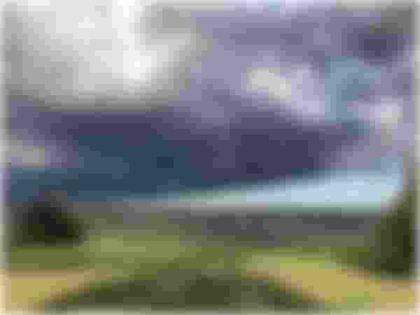
High and middle level clouds have a delicate appearance and rarely cause precipitation. It’s the dark, low ones that signal impending rain or snow.
Atmospheric phenomena

Rainbows are falling rain or suspended water droplets viewed with the sun at your back. Sunlight enters a raindrop and is reflected off the back side as if it were a mirror, going back out the side it entered. The different wavelengths of light are bent on entering the rain drop because it is more dense than the air they left. The shorter wavelengths of light (violet, blue, and green) are bent more than the longer wavelengths (yellow, orange, and red). The wavelengths bend again as they re-enter the air, causing them to clearly separate from one another.
You see a single color from each raindrop so it takes many to make a rainbow. It’s your personal rainbow because even someone standing next to you is seeing light reflected from different raindrops, at different angles. If you see a rainbow in the morning, start looking for an umbrella. Why?
Answer:
In our middle latitudes, weather travels from west to east. With the sun at your back in the morning, you are facing west and looking at weather that is headed your way.
The Belt of Venus or anti-twilight arch is visible shortly before sunrise or after sunset. It is a pinkish glow, 10-20 degrees above the horizon, caused by scattering of the Sun’s rays by tiny particles in the atmosphere. The blue-grey band just above the horizon and opposite the sun is the projection of the Earth’s shadow on the lower layers of the atmosphere.

Additional information is available in Resources under Weather.